
Page path:
- Home
- ...
- INTERCOAST
- Latest News
- Archiv
- News 2015
- 16-03-2015 Acoustic remote sensing survey - A r...
- Acoustic remote sensing survey successfully completed in Tauranga Harbour - A report by Manuela Biondo IC 5
INTERCOAST
Acoustic remote sensing survey successfully completed in Tauranga Harbour - A report by Manuela Biondo IC 5
Another successful INTERCOAST campaign was recently completed in the blue waters of the Tauranga Harbour, a natural tidal estuary located in the Bay of Plenty, New Zealand.
During the past three weeks I had the unique opportunity to survey the dynamic seabed of the Harbour, using advanced underwater acoustic sensors. These devices are popularly used for the continuous definition of seabed features and the study of physical and biological processes. The specific purpose of my research is to assess the efficiency and limitations of acoustic remote sensors in resolving fine-scale roughness changes in the seabed, along short temporal gradients. The study area was located in the proximity of the shipping channel (Panepane point, fig. 1); the sea bottom here is highly diverse in term of biological and sedimentary features; the strong ebb and flood currents continuously remobilize the unconsolidated sediments over each tidal cycle, making this an ideal study site for my research targets.
During the past three weeks I had the unique opportunity to survey the dynamic seabed of the Harbour, using advanced underwater acoustic sensors. These devices are popularly used for the continuous definition of seabed features and the study of physical and biological processes. The specific purpose of my research is to assess the efficiency and limitations of acoustic remote sensors in resolving fine-scale roughness changes in the seabed, along short temporal gradients. The study area was located in the proximity of the shipping channel (Panepane point, fig. 1); the sea bottom here is highly diverse in term of biological and sedimentary features; the strong ebb and flood currents continuously remobilize the unconsolidated sediments over each tidal cycle, making this an ideal study site for my research targets.

Figure 1: study area located between the western side of the shipping channel and the south-eastern side of Matakana Island (Panepane point). All survey lines were oriented S-N, except for one single transect surveyed in both southerly and northerly
directions in order to investigate the effect of the insonification angle.
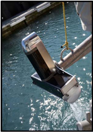
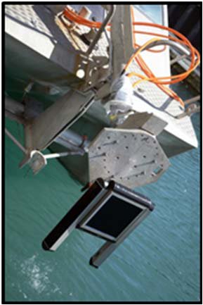
Survey efforts resulted in the production of very high-resolution acoustic images, using a side-scan sonar/sub-bottom profiler parametric system (Innomar, SES-2000 standard plus; fig. 2) and a multibeam echosounder (RESON Seabat 7125; fig . 2 ). Underwater videos and grab samples were also taken for ground-truthing purposes. The innovative integration of multiple hydro-acoustics sensors allowed the collection of different types of information (seabed morphology, sediment types and thickness of surface facies), and will therefore permit the appreciation of how the different physical variables act on the acoustic signal. Continuous time-series data collected over two entire spring and neap tidal cycles, and a multi-frequency acquisition
RESON Seabat 7125 multibeam echosounder
combined sonar/sub-bottom profiler parametric system Innomar,
SES-2000 standard plus
approach, gives this study an experimental character that has the potential to answer several method related questions. Part of the results will be published later this year and hopefully will contribute to current on-going research for better understanding of underwater scattering phenomena, ever-improved accuracy, automation and standardization for acoustic seabed habitats characterization. Results will also serve as a basis for more processes-oriented investigation of sedimentary trends and net transports in the area, giving opportunity for interdisciplinary collaboration within the INTERCOAST group.

Figure 3: the acoustic acquisitions Team at work.
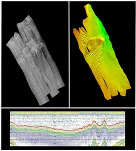
Figure 4: Preliminary outputs from sidescan sonar (top left), multibeam
(top right), and sub-bottom profiler (bottom).
Overall this has been a very valuable experience where I have gained first-hand skills for survey planning, from designing the best method, to choosing the most suitable site and managing money and time. I will treasure what I have learnt from the people around me, who have certainly contributed to my personal and professional growth. I would like to deeply thank University of Bremen, the INTERCOAST group, the Senckenberg Am Meer Institute in Wilhelmshaven and the Faculty of Science and Engineering at University of Waikato for generously providing instruments, vessel, technical, scientific and financial support. I would like to thank all the people and colleagues who worked on-board and contributed to the successful completion of this survey.
Manuela Biondo 12/03/15
Manuela Biondo 12/03/15