
Marine Geotechnics OLD
Research projects and areas
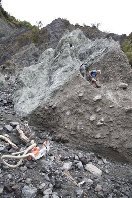
Hellenic subduction zone, Eastern Mediterranean Sea
Active thrusts and backthrusts on the Mediterranean Ridge
For the area south of Crete, a research drilling proposal exists since 1999. The strategy encompasses to tap into an active mud volcano, a backthrust and a thrust fault, all fluid-bearing in nature. An abstract of the proposal #555 can be found on the IODP (Integrated Ocean Drilling Program) website.
As a result of inadequacies within the IODP Science Advisory Structure, which rarely assesses scientific quality alone, this cruise has not been materialised for more than a decade. Instead, two short rsearch expeditions using German RV Poseidon visited the sites. During these endeavours, seafloor outcrops of deep-seated mud domes and fault zones were studied and sampled in the landward portion of the Mediterranean Ridge.
Among the main results of those cruises, namely P410 spring 2011) and P429 spring 2012), are the successful deployment and recovery of five long-term CAT flowmeters, numerous gravity cores as well as in situ T-probe and CPT deployments, and a detailed bathymetric Survey. We can show that the fault gouge material in the deep-seated fault zones of backthrusts is macroscopically very similar to the matrix material of the mud breccia recovered from active mud domes further south. Both mineralogical composition and pore water chemistry hint towards an origin from several kilometres depth, most likely the area of the upper seismogenic zone.
The geothermal gradients in the more hydraulically active mud domes reaches regional peaks of >1000 °C/km, which is also supporting the interpretation of deeply mobilised waters. The chemical pore fluid composition is often enigmatic, as demonstrated byextremely high B, etc.
Details may be found in:
Kopf, A., Bartsch, C., Castellino, J., Fleischmann, T., Haas, S., Ioakim, C., Kirsch, K., Kufner, S.K., Steiner, A., Tryon, M.D., Wiemer, G., Zabel., M., 2012. REPORT AND PRELIMINARY RESULTS OF POSEIDON CRUISE P410: MudFlow (Mud volcanoes and fluid flow in the Mediterranean Ridge Accretionary Complex), Berichte aus dem Fachbereich Geowissenschaften der Univ. Bremen, No. 284: 128 pp.
Kopf, A., Belke-Brea, M., Ferentinos, G., Fleischmann, T., Geraga, M., Kufner, S., Schlenzek, S., Steiner, A., Tryon, M., Wiemer, G., 2012. REPORT AND PRELIMINARY RESULTS OF RV POSEIDON CRUISE P429: MEDFLUIDS: Slope Stability, Mud volcanism, Faulting and Fluid Flow in the Eastern Mediterranean Sea (Cretan Sea, Mediterranean Ridge) and Ligurian Margin (Nice slope), Berichte aus dem Fachbereich Geowissenschaften der Univ. Bremen, No. 286, 80pp.
Submarine landslides in the eastern Mediterranean:FS Poseidon Expedition P336 (May 2006) und P429 (March 2012)
Expedition P336 CRESTS (=CREtan Sea Tectonics and Sedimentology) using German RV Poseidon explored the Cretan Sea, an area north of Crete where exhumed rock from teh forearc high represents an unstable area of the Hellenic Arc. CRESTS aimed at a comprehensive characterisation of the Cretan NE-slope and adjacent subbasins. In teh north, the study area is bordered by the Aegean volcanic islands, which themselves represent loci of submarine mass wasting. The science party was from MARUM Bremen, but also ETH Zürich (Switzerland) and HCMR (Greece).
Main objectives were to illuminate the neotectonic activity of the area, which is attested by
- Micro-seismicity and active normal faults
- large-scale transpressional dynamics
- rapid sediment accumulation, with many turbidites
- episodic landsliding.
In addition, we were looking for zones of potential fluid venting, as known from the forearc region south of the island.
In a broader context, cruise P336 adds to the general understanding of processes in the Hellenic subduction zone, where deformation is accentuated given the indentation of the Libyan promontory. Many former expeditions have focused on the Mediterranean Ridge in the south, however, the Cretan Sea area is mechanically very crucial when looking at the Hellenic subduction zone as a whole.
During a recent expedition, cruise P429 in spring 2012, a second sector at the NW-corner of Crete was investigated geotechnically to characterise submarine slope failure. Along a transect away from Cape Spatha, asmaller scale mass wasting deposits were geophysically imaged, sampled and characterised in situ. CPT-data attest that the upper sediments are fluid-rich and favour mass wasting processes.
Initial results may be found in:
Kopf, A. and cruise participants, 2006.
Report and preliminary results of POSEIDON Cruise P336, Heraklion - Heraklion, 28.04. – 17.05.2006. Berichte, Fachbereich Geowissenschaften, Universität Bremen, No. 253, Bremen, 82 pp (plus Appendices und CD-ROM)
Kopf, A., Belke-Brea, M., Ferentinos, G., Fleischmann, T., Geraga, M., Kufner, S., Schlenzek, S., Steiner, A., Tryon, M., Wiemer, G., 2012.
REPORT AND PRELIMINARY RESULTS OF RV POSEIDON CRUISE P429: MEDFLUIDS: Slope Stability, Mud volcanism, Faulting and Fluid Flow in the Eastern Mediterranean Sea (Cretan Sea, Mediterranean Ridge) and Ligurian Margin (Nice slope), Berichte aus dem Fachbereich Geowissenschaften der Univ. Bremen, No. 286, 80pp (plus Appendices and CD-ROM)
")
")
")
Ligurian Basin
Along the Ligurian Margin, S France, the European Multidisciplinary Seafloor Observatory, relies on the ANTARES-Neutrinotelescope and seafloor cable, plus a future shallow-water cable south of Nice. Main aim of latter is a more profound understanding of submarine landslide processes.
In 2007 two expeditions with MARUM participation were carried out in the area:
RV Meteor M73/1 (July-August)
RV L'Atalante PRISME (Oct-Nov).
Both cruises had the objective to study the upper slope where a submarine failure damaged the international airport of Nice in October 1979, which also caused a tsunami. Other landslides in water depths down to 2000 m as well sedimentary processes in the Var Canyon complemented the research programme.
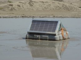
A third expedition took place in summer 2009 using RV Poseidon (P386), where two long-term piezometers were placed into the Nice airport slide and adjacentmetastable slope. We also carried outdemo missions in the framework of EU-project ESONET.
The piezometers were revisited twice on French vessel L'Europe, where an osmo-sampler probe (MARUM) and a soft-sediment-strainmeter (IFREMER) were installed. The Nice has now a the first multi-disciplinary landslide observatory.
Scientific drilling has been proposed (see IODP proposals 685-full by Henry et al., and 796-full by Kopf et al., 2012).
In 2007 two expeditions with MARUM participation were carried out in the area:
RV Meteor M73/1 (July-August)
RV L'Atalante PRISME (Oct-Nov).
Both cruises had the objective to study the upper slope where a submarine failure damaged the international airport of Nice in October 1979, which also caused a tsunami. Other landslides in water depths down to 2000 m as well sedimentary processes in the Var Canyon complemented the research programme.
A third expedition took place in summer 2009 using RV Poseidon (P386), where two long-term piezometers were placed into the Nice airport slide and adjacentmetastable slope. We also carried outdemo missions in the framework of EU-project ESONET.
The piezometers were revisited twice on French vessel L'Europe, where an osmo-sampler probe (MARUM) and a soft-sediment-strainmeter (IFREMER) were installed. The Nice has now a the first multi-disciplinary landslide observatory.
Scientific drilling has been proposed (see IODP proposals 685-full by Henry et al., and 796-full by Kopf et al., 2012).

Nankai Trough subduction zone and Shimanto complex, Japan
The project NanTroSEIZE (Nankai Trough Seismogenic Zone Experiment) of IODP represents one of the most ambitious geoscientific research endeavours ever. Using the Riser-based DV Chikyu, a transect of holes will study the Nankai-Trough accretionary complex and its seismogenic zone in ca. 5,5 - 6 km depth below seafloor.
In more than a dozen expeditions several portions of the subduction system were studied, including the downgoing plate (Sites C0011, C0012) as well as the accretionary prism (C0001-C0008, C0010, C0018) and the Kumano-forearc basin (C0009). In addition, long-term observatories got installed at Sites C0010 and C0002. The MARINE GEOTECHNICS was actively involved in more than half of those expeditions as shipboard scientists and also has worked/is working on materials from all drill holes. By doing so, we cover the fields of sedimentology and grain size analyses, strain analysis on CT-scans of the cores recovered, deformation experiments on discrete core samples, permeability tests on small mini core samples, and development and installation of long-term borehole instruments.
During one of the most successful expeditions with DV CHIKYU within the NanTroSEIZE project, Expedition 332, we recovered the first long-term observatory (SmartPlug; see In situ instruments page of MARINE GEOTECHNICS group) after 15 months of measurement and installed a second, more sophisticated instrument (GeniusPlug) at Site C0010. We also installed one of the most complex CORK borehole observatories at Site C0002 and visited the wellhead by ROV to successfully download data.
Details may be found in:
Kopf, A., Araki, E., Toczko, S., and the Expedition 332 Scientists, 2011. Proc. IODP, Initial Reports 332: Washington, DC (Integrated Ocean Drilling Program Management International, Inc.), 60 pp. doi: 10.2204/iodp.pr.332.2011
Kopf, A., Araki, E., Toczko, S., and the Expedition 332 Scientists, 2011. Proc. IODP, Initial Reports 332: Washington, DC (Integrated Ocean Drilling Program Management International, Inc.), 190 pp. doi: 10.2204/iodp.proc.332.2011
as well as for the SmartPlug and GeniusPlug in:
Kopf, A., Hammerschmidt, S., Saffer, D.M., Lauer, R., Davis, E.E., LaBonte, A., Meldrum, R., Heesemann, M., Macdonald, R., Toczko, S., Wheat, C.G., Jannasch, H., Edwards, K., Haddad, A., Orcutt, B., Villinger, H., Araki, E., Kitada, K., Kimura, T., Kido, Y., 2011. The SmartPlug and GeniusPlug: Simple retrievable observatory systems for NanTroSEIZE borehole monitoring. Proc. IODP, vol 332, doi:10.2204/iodp.proc.332.105.2011 (21pp.)


Kumano Basin mud volcanoes
Approximately 90% of the seismic moment on Earth is released in often devastating subduction zone earthquakes (EQs). In the Integrated Ocean Drilling Program (IODP), the study of seismogenesis along an active convergent margin plays a key role in the form of a multi-expedition effort named “NanTroSEIZE” (Nankai Trough Seismogenic Zone Experiment). To date, eight expeditions (IODP Expeditions 314-316, 319, 322, 326, 332-333) drilled 12 sites along a transect from the incoming plate across the frontal accretionary prism to the forearc basin. Two holes are currently equipped with long-term instruments (C0002, C0010). The project Sonne SO222 MEMO, MeBo drilling & in situ long-term Monitoring offshore Japan (Nankai Trough Accretionary Prism), aims to extend the long-term monitoring efforts to active mud volcanoes in the northern Kumano Basin. These features carry gas hydrates and deep-seated fluids, most likely tapping into the seismogenic zone at a depth of several km below seafloor, and are also overlying an area of high strains and a locked plate boundary-thrust. Cruise SO222 sampled both mud volcanoes and background sediments and installed long-term monitoring devices in key locations.
The main results of the two legs SO222A and SO222B include:
- The discovery of 5 new, previously not reported mud volcanoes, so that there are 13 MVs in the Kumano Basin now;
- Gas hydrate presence in many of the features;
- Enigmatic pore fluid signatures with high B, Li and Sr, but low Mg in the pore waters, suggesting deep-seated fluid origin;
- Successful installation of of 4 MeBo borehole observatories in a total of six holes drilled in appx. 2 km water depth;
- Successful installation of six CAT flowmeters on the most active mud volcanoes in the Kumano field;
- Successful operation on so-called MeBoCORK observatories with ROV Quest;
- Recovery of gravity and MeBo cores as well as TV grab that contain a suite of clasts in the mud breccias that span the range from soft to hard rocks and cover all grain size classes of sedimentary rocks, but also comprise magmatic materials and deformed rocks;
- Gas composition attests a biogenic origin for the majority of the mud domes visited;
- Heat flow data attest active flow in at least some of the mud domes; however,
- No active venting was neither observed by acoustic techniques nor by direct observation with ROV or TV-grab.


")
North Sea and Baltic Sea
The offshore research platform FINO1, located appx. 45 km north of the barrier island Borkum, serves to study various crucial parameters in wind energy use, e.g. for alpha ventus windfarm or future installations. Time series data are recorded primarily to monitor fluctuations in wind force and direction, movement and deformation/wear of teh platform, meterological parameters, hydrographical parameters, and biological observations. FINO1 is founded in appx. 30 m water depth, has its own energy supply, and transmits all data in quasi-real time via a radio link. Its anticipated lifetime is 20 years.
MARUM Bremen (Marine Geotechnics working group) is a partner and has installed a small seafloor observatory on the jacket foundation in late summer 2006. It comprises a seabottom base station with underwater mateable connectors that can host up to 10 devices, which are in turn supplied with energy and data transmission capability. Initially, a long-term probe was deployed by scuba divers (ca. 2m subseafloor depth), which is monitoring pore pressure and temperature transients as well as deformation (Tilt) in the underground as a function of (a) strain caused by platform movement, (b) tides, and (c) sediment dynamics/scour.
The Marine Geotechnics working group is also working in the offshore windfarm Alpha Ventus, which was erected in 2010 and which is currently studied in a collaborative project with BSH Hamburg, funded by BMU (German Ministry for the Environment). Here, main research focus is the in situ characterisation of the stability of the sediment as a function of movement and sediment dynamics (erosion/scour and redeposition) close to the widnmills.


Alpine Fault, New Zealand
The Alpine Fault (Southern Alps, Neuseeland) represents the active plate boundary between the Pacific and Australian Plates. It generates earthquakes of substantial magnitude and is charcterised by rapid exhumation. The fault shows spectacular surface outcrops on land and is a target of future scientific drilling by the International Continental Drilling Project (ICDP). Pilot drilling (DFDP holes 1A and 1B) to <200-300m helped to recover pristine fault gouge core as well as the hangingwall and footwall to the fault. Drilling also served to prepare for a deep ICDP hole in 2013 or 2014. At MARUM, core materials are studied using ring shear and heated direct shear tests (HYDSPA) in order to characterise strength, frictional stability, and mechanical and mineralogical alteration.
Gibraltar Arc
Expedition SO175 using FS Sonne aimed for a multidisciplinerary geoscientific approach with an international group of researchers. Methods covered the entire span from geophysical data acquisition (seafloor mapping, echography, seismic reflection), sediment coring at sites of active fluid venting, in situ heat flow measurements across the entire length of the Gibraltar thrust wedge, the deformation front, landslide bodies, and mud volcanoes, and finally the deployment of a long-term pore pressure probe. Video-supported operations helped to identify fluid vent sites, regions with tectonic activity, and other attractive high priority targets. Qualitative and quantitative examinations took place on board and are continued on land with respect to pore pressure variation, geomicrobiology, sediment- and fluid mobilization, geochemical processes, faunal assemblages (e.g. cold water corals), and gas hydrates (flammable methane-ice-crystals). Main focus of the expedition has been a better understanding of interaction between dynamic processes in a seismically active region region with slow plate convergence.
In the context of earthquake nucleation and subduction zone processes, the SO175 research programme had a variety of goals, such as:
• To test the frictional behaviour of the abyssal plain sediments.
• To explore the temperature field of the 1755 thrust earthquake event via heat flow measurements.
• To assess the role of fluid venting and gas hydrate processes control slope stability and mud volcanic activity along the Iberian continental margin.
• To measure isotope geochemistry of pore waters and carbonates of deep fluids.
• To quantify microbial activity in Gibraltar wedge sediments.
• To test whether microseismicity in the area corresponds to in situ pore pressure changes.
• To find out if enhanced heat flow max be indicative of active subduction.
Initial tentative results during the cruise suggest that there is a component of active thrusting at the base of the wedge, as attested by heat flow data. Based on mostly geochemical evidence, mud volcanism was found less active than previously assumed. Highlights from post-cruise research include the successful deployment of the long-term station and high frictional resistance of all incoming sediment on the three abyssal plains.


Chile Margin
Along the continental margin of central Chile, we observe variable sediment accumulation rates, tectonic movements owing to subduction, megathrust earthquakes, gas hydrate processes and submarien landslides.
In a collaborative study with colleagues from Univ. Bremen (Prof. Heinrich Villinger) the in situ properties of slope sediments were characterised using a heat flow probe and CPTu lance (see map).
In a second study, the area of the 1960 M9.1 earthquake down to teh Chile Triple Junction was studied from a physical and sedimentological point of view. The work was based on cruise SO181 with RV Sonne, which was funded by BMBF (German Ministry for Research and Education). The study attested that the composition of the deep sea trench deposits varies systematically in their mineralogical composition from N to S. These changes consequently cause variable frictional resistance in teh deeper subduction zone, which in case of an earthquake may also cause different stress release patterns.
At present, a collaborative project between MARUM, ETH Zürich (Switzerland) and Univ. Ghent (Belgium) examines lakes in the onshore portion of the Chilean Forearc. These lakes show evidence for earthquake-triggered mass wasting deposits. Those slides were geophysically characterised and then revisited with a gravity corer and a free-fall CPTu device.
")

Azerbaijan
Dashgil mud volcano is one of the largest and most active of a total of >200 mud domes in Azerbaijan. It is located close to teh Caspian Sea and emits gas (largely methane) more or less continuously. Given that historical evidence exists that mud volcanoes in the Caucasus area became more active prior and during periods of seismicity (in particular large EQs), a group at BGR Hannover (led by BGR Dr. Georg Delisle) had started to monitor the gas emission in the crater lakes of Dashgil since 2005.
In this project, MARUM Bremen joined in and helped instrumenting the larger of the two crater lakes with a diameter of appx. 28 m and 10-12 m depth. The lake has two areas where gas bubbling is seen, and these areas were equipped with two large, submerged tents with an opening to bundle the gas flow. Above the opening, gas fluxmeters are quantifying the emissions. In the central part of the lake, a pore pressure and temperature probe is installed. The hypothesis to be tested is whether pore pressure transients correlate with those in methane emission and local seismicity.
Two manuscripts have been published by the MARUM Marine Geotechnics group:
Kopf, A., Stegmann, S., Delisle, G., Panahi, B., Aliyev, C.S., Guliyev, I., 2009. In situ CPTU experiments at active Dashgil mud volcano, Azerbaijan: Evidence for excess fluid pressure, updoming, and possible future violent eruption. Marine Petroleum Geology, 26: 1716-1723
Kopf, A., Delisle, G., Faber, E., Panahi, B., Aliyev, C.S., Guliyev, I., 2010. Long-term in situ monitoring at Dashgil mud volcano, Azerbaijan: A link between seismicity, pore pressure transients and methane emission. Int. J. Earth Sciences, 99, Supplement 1, 227-240, DOI: 10.1007/s00531-009-0487-4
")
")
Lake Lucerne/Switzerland
In a joint project with ETH Zürich we carried out in situ measurements with the free-fall CPTu probe to geotechnically characterise the slope sediments of Lake Lucerne. In teh area, earthquake activity and resulting tsunamis have been reported, the first being associated with major seismic events as a consequence of Alpine orogeny.
Among the publications from this project, please refer to:
Strasser, M., Stegmann, S., Bussmann, F., Anselmetti, F.S., Rick, B., Kopf, A., 2007. Quantifying subaqueous slope stability during seismic shaking: Lake Lucerne, Central Switzerland, as model for ocean margins. Marine Geology, 240: 77-97.Stegmann, S., Strasser, M., Anselmetti, F.S., Kopf, A., 2007. Geotechnical in situ characterisation of subaquatic slopes: The role of pore pressure transients versus frictional strength in landslide initiation. Geophysical Research Letts., 34/7, doi:10.1029/2006GL029122.

Cyclic deformation experiments
In order to understand processes that govern pore volume transients owing to stress changes, we are using a Nuclear Magnetic Resonance (NMR) - apparatus at GGA Hannover to quasi-continuosly monitor pore size distribution in a non-destructive manner. The key issue in teh experimental setup is to transfer the stress onto the sample when it is in the core of the permanent magnet without affecting the magnetic field. For this purpose, we have designed a specimen chamber of carbon fibre-bearing compound material which can bear substantial pressure without being magnetised at all. The specimen is cylindrical and can be loaded statically and dynamically using pumps. The idea is to monitor pore volume evolution over time while the stress is increased until the sample fails.
Aliquots of those samples are statically and dynamically tested at lower stress in the DTTD.
Among the publications to this topic so far, please refer to:
Kreiter, S., Mörz, T., Strasser, M., Lange, M., Schunn, W., Schlue, B.F., Otto, D., Kopf, A., 2010. Advanced Dynamic Soil Testing – Introducing the new MARUM Dynamic Triaxial Testing Device. In: Mosher, DC., Shipp, C., Moscardelli, L., Chaytor, J., Baxter, C., Lee, H., and Urgeles, R. (eds.), Submarine Mass movements and their consequences IV. Advances in Natural and Technological Hazards Series, Springer: 31-42.
Wiemer , G., A. Reusch, M. Strasser, S. Kreiter, D.Otto, T. Mörz, A. Kopf, 2011. Static and cyclic shear strength of cohesive and non-cohesive sediments In: Submarine Mass Movements and Their Consequences, Springer, Kyoto, Japan: 111-122
")
")
Ems estuary/German Bight
Like many other tidally influenced estuaries in the German Bight, the Ems is suffering high input of fine-grained, organic rich suspensions known as fluid mud. The abundance of those materials, in particular when partly consolidated, lowers the nautical depth, hampers shipability, and causes substantial cost for dredging activities every year. The Marine Geotechnics working group tries to shed light on fluid mud dynamics by using sophisticated sampling techniques (and subsequent rheometric characterisation) as well as in situ technologies.
For details, see:
Seifert, A., Kopf, A., 2012. Modified Dynamic CPTU Penetrometer for Fluid Mud Detection. Journal of Geotechnical and Geoenvironmental Engineering, 138: 203–206.
For details, see:
Seifert, A., Kopf, A., 2012. Modified Dynamic CPTU Penetrometer for Fluid Mud Detection. Journal of Geotechnical and Geoenvironmental Engineering, 138: 203–206.
